


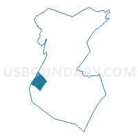
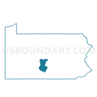
LINCOLN TWP Voting District, Huntingdon County, Pennsylvania
About
Outline

Summary
| Unique Area Identifier | 659925 |
| Name | LINCOLN TWP Voting District |
| County | Huntingdon County |
| State | Pennsylvania |
| Area (square miles) | 20.95 |
| Land Area (square miles) | 18.86 |
| Water Area (square miles) | 2.09 |
| % of Land Area | 90.03 |
| % of Water Area | 9.97 |
| Latitude of the Internal Point | 40.33646490 |
| Longtitude of the Internal Point | -78.18569170 |
Maps

Graphs
Select a template below for downloading or customizing gragh for LINCOLN TWP Voting District, Huntingdon County, Pennsylvania


Neighbors
Neighoring Voting District (by Name) Neighboring Voting District on the Map
- HOPEWELL TWP DIST HOPEWELL, Huntingdon County, PA
- HOPEWELL TWP DIST PUTTSTOWN, Huntingdon County, PA
- HUSTON TWP Voting District, Blair County, PA
- MARKLESBURG Voting District, Huntingdon County, PA
- PENN TWP Voting District, Huntingdon County, PA
- TODD TWP Voting District, Huntingdon County, PA
Top 10 Neighboring County Subdivision (by Population) Neighboring County Subdivision on the Map
- Huston township, Blair County, PA (1,336)
- Penn township, Huntingdon County, PA (1,077)
- Todd township, Huntingdon County, PA (952)
- Hopewell township, Huntingdon County, PA (586)
- Lincoln township, Huntingdon County, PA (338)
- Marklesburg borough, Huntingdon County, PA (204)
Top 10 Neighboring Place (by Population) Neighboring Place on the Map
Top 10 Neighboring Unified School District (by Population) Neighboring Unified School District on the Map
- Huntingdon Area School District, PA (20,447)
- Spring Cove School District, PA (14,446)
- Tussey Mountain School District, PA (7,329)
Top 10 Neighboring State Legislative District Lower Chamber (by Population) Neighboring State Legislative District Lower Chamber on the Map
- State House District 80, PA (62,593)
- State House District 78, PA (60,809)
- State House District 81, PA (60,600)
Top 10 Neighboring State Legislative District Upper Chamber (by Population) Neighboring State Legislative District Upper Chamber on the Map
Top 10 Neighboring 111th Congressional District (by Population) Neighboring 111th Congressional District on the Map
Top 10 Neighboring Census Tract (by Population) Neighboring Census Tract on the Map
- Census Tract 113, Blair County, PA (5,938)
- Census Tract 9506, Huntingdon County, PA (4,120)
- Census Tract 9508, Huntingdon County, PA (3,684)
- Census Tract 9513, Huntingdon County, PA (2,411)